Aucun produit
Les prix sont TTC
 Zoomer


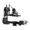
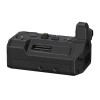
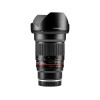
Dji Camera DJI-Zenmuse-L1 + LiDAR + 20MP CMOS, RGB
Dji
DJI Zenmuse L1 with LiDAR and 20MP CMOS, RGB Camera - DJZP02
The highlights of the Zenmuse L1 are:
All-in-one solution: integrates a Lidar module, an RGB camera and a high-precision IMU.
High Accuracy: Vertical - 5cm; Horizontal ? 10 cm (with a flight height of 50 m).
DJI Zenmuse L1 with LiDAR and 20MP CMOS, RGB Camera - DJZP02
The DJI Zenmuse L1 is an affordable and easy-to-use enterprise aerial LiDAR payload designed for DJI's flagship commercial drone, the M300 RTK.
The Zenmuse L1 integrates a Livox sensor, high-precision IMU, a one-inch 20MP CMOS visual camera with mechanical shutter, and a 3-axis stabilized gimbal system.
Combine it with the M300 RTK and DJI Terra mapping software for a highly efficient all-in-one aerial LiDAR solution to obtain 3D point clouds for high accuracy and detailed reconstruction.
The Zenmuse L1 can be used across a range of vertical industries, such as energy, AEC, forestry, public safety and more.
The highlights of the Zenmuse L1 are:
All-in-one solution: integrates a Lidar module, an RGB camera and a high-precision IMU.
High Accuracy: Vertical - 5cm; Horizontal ? 10 cm (with a flight height of 50 m).
Efficient: covers 2 km² in a single flight (10 m/s flight speed, 100 m flight height, 20% lateral overlap ratio).
High-density dot cloud: 240,000 dots/s effective.
Multiple Renders: Supports three renders (double and triple renders, point cloud density 480,000 points/sec).
Measurement range: 450 m maximum (80% reflectivity 0 klx).
Live Point Cloud View: Able to view and measure live point clouds.
Weatherproof: IP44 rated, allowing operators to collect data in rainy or foggy environments.
DJI Ecosystem: Uses DJI Terra for data post-processing.
° Optimize data collection
The Zenmuse L1 integrates a powerful and ultra-lightweight Livox Lidar module with a 70° FOV, a high-precision IMU, and a 20-megapixel camera with a 1-inch CMOS sensor.
The Zenmuse L1 can generate true-color point cloud models in real time or capture a large area (up to 2 km²) of point cloud data in a single flight.
With a Point Rate of 240,000 points per second and a detection range of 450 meters, the ease and speed of acquiring quality Lidar data is unprecedented.
The module supports both line scan mode and non-repetitive scan mode, an exclusive technology developed by Livox.
This will provide complete coverage of the area of interest in a very short time and allow the sensor to acquire data in any direction, rather than along a defined plane.
The Zenmuse L1 Lidar solution can easily penetrate tree canopies and foliage.
When the drone unexpectedly loses GNSS signal, the DJI Zenmuse L1 can continuously use the visual assistant camera to receive orientation data and maintain system accuracy within a short period of time.
° Additional features of DJI Zenmuse L1
Payload Health Management System: Integrated into the DJI Pilot app, the Payload Health Management System records the total usage time of the Zenmuse L1, as well as the number of rotation times, error logs, and product maintenance tips.
Real-time Awareness Flight: The LiDAR sensor can obtain the aircraft's height above the ground in real-time and perform terrain awareness flight to ensure data quality and flight safety.
Accuracy Report: After the flight, DJI Pilot will generate an inspection report, display the point cloud data quality, photo location, photo number and RTK status, so that the pilot can confirm the quality of the place data.
° DJI Zenmuse L1 ? Enhance aerial detection
The LiDAR sensor has a wide range of uses.
Generate accurate models and reconstructions
The DJI Zenmuse L1 is aimed at commercial drone users looking for high-precision aerial survey solutions.
The LiDAR sensor can empower customers in energy, AEC, public safety, architecture/heritage, and forest management.
Weight: 10 kg
Promotions